HIRAM
• Designed specifically to address defined Highway Authority resilience needs
• Open source, affordable mapping (GIS) and database
• Facilitates consistent, un-biased assessment of resilience schemes
• 100% customer defined reports including costed business cases
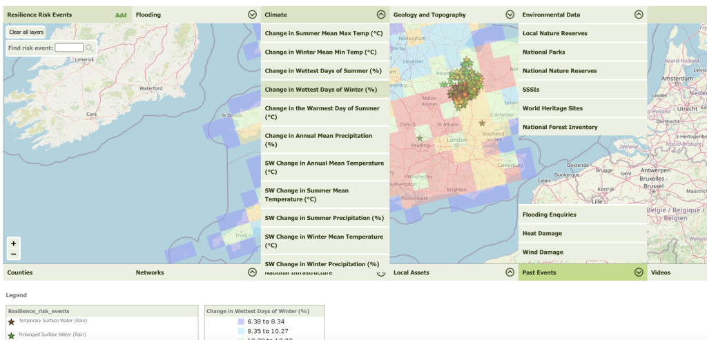
In 2014, the Environment Agency (EA) in conjunction with the South West Highways Alliance (SWHA) went out to competitive tender for the development of a Highways Resilience Modelling Tool. This tool was identified as a key system required by Local Highways Authorities to respond to the climate readiness challenges set in the Secretary of State for Transport’s “Transport Resilience Review”. Initially their brief required the development of a web-based mapping tool to allow users to share resilience information for coordinating their operational responses, with an Excel spreadsheet system to be used for the data capture of “resilience risk events”.
Shortly after the award of contract in December 2014, WPM identified an alternative solution which would offer better value for money and better outcomes for the client. By utilising open-source mapping and database software, WPM proposed that the client could achieve better data standards and security, and more mapping functionality for the same, very limited, budget within the same delivery timescale.
Since its release in 2015, HIRAM has been used by a number of Local Authorities in a variety of ways, from identifying and prioritising their own work, to demonstrating compliance with Incentive Fund self-assessments and bidding for central government funds. HIRAM’s most notable success story to date is that the South Gloucestershire and Bristol Highways Authorities worked together to improve resilience on a cross-boundary approach and, by using HIRAM’s built-in business-case reports as the foundation for their bid, secured £3.35M of funding from the Department for Transport’s Flood Resilience Challenge Fund.
While “challenge funding” now seems to be less relevant for Highways Authorities, we have recently had feedback from our users that HIRAM remains a very useful tool for identifying, quantifying, and pricing climate risks and for the calculation of economic benefits to the wider community of completing resilience schemes. There has also been positive feedback that HIRAM output could be recognised favourably by Government in respect to the Third National Adaptation Programme (NAP3).
StormChain
• Android and IOS Smartphone Apps
• GPS asset location and site photos
• Real time upload from site to cloud storage
• 100% customer defined reports
In 2021, the Local Government Technical Advisers Group published new guidance for assessing Highway Networks in response to extreme impact events (e.g. significant and widespread, climate-driven storm damage). In recognition of the importance of the highway as a community lifeline, this document constituted the first structured approach to introducing a methodology to identify and assess damaged highways assets, build wider situational awareness, and support a risk-based prioritisation for asset repair.
While the Guidance provided a set of templated, paper-based forms for recording asset location, damage assessment and the impact (risks and consequences for the road network), being a first of its kind approach, there were no IT solutions available to record the data required, transfer that data to a centralised co-ordination point or effectively support the operational needs of prioritising an effective emergency response.
Knowing that the guidance was about to be published, and following a recommendation from the former chair of the South West Highways Alliance, the author and a sponsor of the Guidance approached WPM in mid-2020 regarding the feasibility of developing a system which would initially collect data using tablet-based PDF forms, would allow the electronic transfer of data to a centralised server and would produce all of the reports required to support the operational decision making requirements of the Guidance – including the scoring and ranking of the damaged assets.
Having met, or even exceeded, all expectations of the client, WPM have been engaged as long-term technology partners for the development and maintenance of Stormchain and manage their cloud hosting. In 2021 the PDF forms were dropped for data collection and Stormchain moved to a completely new Android-based smartphone app. Through 2022/23 this app was also rolled out on IOS. To date WPM continue to refine the operations-room website and reports building on customer feedback and to improve the smartphone apps following client identified enhancements.
RouteShoot
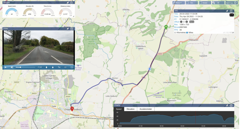
• 100% original, innovative technology developed in-house
• Smartphone Apps (Android and IOS) with cloud data and content management system
• Accurately located GPS-referenced video capturing route surveys or individual images
• Back-end Machine Learning for image recognition
RouteShoot was created in response to customer needs. On a regular basis clients wanted to survey many miles of road in order to be able to assess condition, clarify defects or ensure contractors had delivered maintenance work, additionally those carrying out maintenance work on new commissions needed to understand latent defects and responsibilities.
In early 2012, developments in technology – which saw full 1080p HD video recording and accurate GPS incorporated into a smartphone – meant that it was possible to replace existing, expensive, and technology-intense solutions available only through 3rd party specialists with ubiquitous technology that most people owned already and were proficient in operating. By May 2012 it was clear that we could achieve equivalent geo-referenced video standards by using smartphones and the name “RouteShoot” was given to the product.
Initially developed with a view to supporting the needs of the roads maintenance sector, RouteShoot has been proven in multiple infrastructure industries worldwide in both the public and private sectors. It is an essential tool for managing risk in industries that have to look after assets over a distributed network. This includes Oil companies in Africa, Major Utilities companies in the USA, The World Bank in the Philippines, and highways authorities in the UK such as Dorset County Council, East Sussex Highways and Transport Scotland.
The benefits of RouteShoot are well-established for businesses needing to make location-referenced image (video or photo) records with the true value often being realised when it is shared with other systems. RouteShoot supports the Open Geospatial Consortium (OGC) standards as a default. By making use of the Web Map Service (WMS) and Web Feature Service (WFS) protocols, RouteShoot data can be securely exposed and linked directly to 3rd party stakeholder.